NORTHWEST AFRICA AND TIMBUCTOO,
by Felix A. Mathews, United States Consul-General At Morocco,
Journal of the American Geographical Society of New York,
Vol 13, 1881, p.211-219:
PART II.AN ACCOUNT OF TIMBUCTOO.
From time immemorial Timbuctoo [Timbuktu, Tombouctou] has been considered as the great emporium of Central Africa, having carried on an extensive and lucrative trade with Barbary and other North African maritime states, from Morocco to Egypt.
This trade of late years has somewhat declined, and has been carried on by means of acabahrs, or accumulated caravans, which cross the desert of Sahara between the months of September and April inclusive. The largest caravan [Azalai] which crosses the desert is the one from Morocco, and proceeds from Teneluf, in the confines of the desert, once a year in the month of October, and consists of about ten thousand camels, of which only twenty per cent. carry merchandise. The rest proceeds from Tandeny [Taoudenni], in the centre of the desert, where they load with salt.
Besides this, there are many other caravans composed of one or two hundred camels engaged in transporting the various articles of commerce. The effects which they take to Timbuctoo and the Soudan are various kinds of linens, cotton goods, white and blue salanpores [fish], American cloth and long cloth, sugar, tea, glasses, coral beads, amber beads, pearls, shells, silks, brass nails, wool and cotton manufactures of Fez [Fes], and Morocco nutmegs, clove and ginger, cowries and a considerable quantity of tobacco, keef [kief, cannabis resin] and salt.
The produce of Soudan returned by these caravans for the above articles, consists in gold dust and gold trinkets from Wangara and Jinnie [Djenne, Dienné or Jenne], ivory, ostrich feathers, gum of Senegal, gum arabic, incenses, Soudan blankets, and slaves from Wangara and Housa [Hausa, Houssa].
The value of each camel-load is estimated at $250, consequently the value of the merchandise transported annually from Morocco by the great akabahr may be estimated at $500,000 and at $150,000 that of the small caravans, amounting to $650,000, the total value of the merchandise conveyed to Timbuctoo. Of this sum seventyfive per cent. belongs to the camel drivers of Sus, who transport salt from Tandeny to Timbuctoo, and twenty per cent, of the camels are sold at this place, as the return goods being light, they require a much less number of camels to perform their traverse journey to Morocco.
The great akabahr is dissolved at Timbuctoo, the merchants returning in distinct groups and by various routes.
At present there are four frequent routes from Timbuctoo to Wadnoon, which are:
1st. By Tisity and Wallatta [Oualata, Walata, in Mauritania].
2d. By Hammada, Teneluf, Tzidy, Tandeny and Arawan [Araouane].
3d. By the Boryle in the Ulad-Bu Oxra, Awin, Tirkis, Aits, Uxa and Wallatta.
4th. By Amayett, Teeky, Ulad, Ulad Tedlary, Ulad Dlinsa, Tiris, Waddy,
Yedama and Wallatta.
According to information from merchants and from Ali el Saharawi, the oldest desert guide, the itinerary in going with the Begowy (desert camels) is as follows:
| From | Wadnoon to Tiris | 12 | days |
| " | Nammandy to Yedama | 4 | " |
| " | Yedama to Wallatta | 4 | " |
| " | Wallatta to Timbuctoo | 10 | " |
| | | 30 | days |
With the ordinary camels from sixty to ninety days are employed in crossing the desert.
The tribes inhabiting the territory between the river Draa and the Tiris are independent and warlike, and they will oppose the access of Europeans into the interior of their country. The authority of the sons of Sheik Ben Beiruk only reaches to the Tiris.
The country extending from Wad Draa (river Draa) to Sackia el Hamra [Saguia el Hamra] is very fertile; from here to Cape Bogador [Cape Bojador] it is composed of sandhills, and from this cape it descends to an immense plain called El Yuff, extending some five hundred miles, which with desert camels they traverse in twelve days. This plain is one hundred and twenty miles in width.
The boundaries of El Yuff are inhabited during four months of the year, in the spring, when the Arabs take their cattle to pasture towards the Gralatzy, on these grounds fertilized by the rains of winter. The amarand or gum arabic plant is found on the plains of El Yuff.
The tribes which encamp on the El Yuff during the spring are those from Dibushaty, Ulad-Ahal-Atzmanu, Taganet, Ahal-BrikAllah, Zoowich, and from the West Ahal-el Hodh, Ulad Dleim, Arusin and Ulad Zawari.
The three great tribes of the desert are the Arab Hassan, El Zonaya, and El Lahma. The El Zonaya is a quiet and peaceable tribe, the El Lahma is warlike and rich, and the Arab Hassan is a tribe of dreadful reputation, living off the plunder of the caravans which they* continually attack.
The ostrich, antelope and gazelle make their appearance on the plains of the Yuff soon after the accumulated rains of winter are absorbed. During this season the most valued ostrich feathers are gathered.
Fresh water is found near the surface of the ground from El Yuff to Yedama, from Yedama to Wallatta the water found is salt, and from Wallatta to Timbuctoo the water is again potable near the surface.
It is asserted by those who have crossed the desert during the last forty years, that the great fatigues and mortality of the transit have lately very much diminished. The Arabs attribute this improvement to the free use of tea, which of late has been introduced in all the caravans. They also maintain that the travelling conditions of the desert are much improved, the water in the skins lasting longer, as for some unknown reason the hot winds denominated "shume" are not so violent as in former periods.
In 1815, a caravan, proceeding from Timbuctoo to Tafilet [Tafilalt], encountered the terrible hot winds, so violent that the water in their skins was exhaled. Disappointed in not finding water at one of the usual watering-places, horrible to relate, the whole of the persons belonging to it, 3,500 in number, besides 2,000 camels, perished of thirst! Calamities of this sort account for the vast quantities of human and other bones which are found mingled together in various parts of the desert.
The intense heat of the sun, aided by the vehement and parching wind driving the loose sand along the boundless plains, gives to the desert the appearance of a sea, the drifting sands resembling the ocean waves; hence aptly denominated by the Arabs El Bahar bella maa a sea without water.
In their tiresome journey, the akabahrs do not proceed in a direct line across the trackless desert to their destination, but turn occasionally eastward or westward, according to the situation of certain fertile, inhabited and cultivated spots, interspersed in various parts of Sahara, like islands in the ocean, called by the Arabs El walis (oasis). These serve as watering places, as well as to refresh and replenish the hardy and patient camel. The akabahrs rest on these oasis several days.
The akabahrs cross the desert under convoy, the "stata" being two or more Arabs belonging to the tribe through whose territory the caravan passes. Thus, in passing the territory of Ulad-el-HodhAbbusebah, they are accompanied by two sebayhees or people of that country, who on reaching the confines of the territory of Ulad Deleim [Oulad Delim], receive a remuneration, and return, delivering them to the protection of two chiefs of Ulad Deleim, these again conducting them to the confines of the territory of the Moraffra Arabs, to whose care they deliver them, and so on, till they reach Timbuctoo. Any assault made against the akabahr during this journey while in charge of the stata aforesaid, is considered an insult to the whole clan to which the stata or convoy belongs, and for which they never fail to take ample revenge.
Besides these grand accumulated caravans, there are other flying caravans which cross the desert in much less time; they take with them a sufficient number of female camels (Niag), to supply them with food, they living altogether on the milk of that animal.
It is not ascertained when the communication between Barbary and Soudan was first opened, yet it is certain that the enterprising expedition of Muley Arsheede [Moulay al-Rashid, Sultan of Morocco from 1666 to 1672], Emperor of Morocco, in 1670, encouraged the exchange of commodities and caused the establishment of the company of Morocco merchants from Fez, as well as that of their factory at Timbuctoo, which continued to increase and flourish until of late, when it declined.
Sid Ali, on his flight from Muley Arsheede, after obtaining permission from the negro king of Bambara [Bamana], settled with his numerous followers at Timbuctoo and established a Moorish garrison, until the death of Muley Arsheede, when he returned to Barbary.
Muley Ismael [Moulay Ismaïl, Ismail Ibn Sharif, Sultan of Morocco from 1672 to 1727], Emperor of Morocco, established his power in Timbuctoo, and met with no opposition in putting that place under contribution. Having sent fresh troops to occupy the Moorish garrison there, the inhabitants were glad to make a contribution in exchange for the protection and power which it afforded them, for, previous to this, they had been subject to continual depredations from the Arabs of the adjacent country, to whom they paid tribute as a security to their caravans, which were constantly passing the country of these Arabs, who are of the race of Brabeeshe.
In the year 1727, Muley Ismael died. After his decease the tribute was not regularly transmitted, and his successors, having no means of exacting it, it was entirely discontinued to this day. The Moorish garrison, too, intermarrying with the natives and dispersing themselves about the vicinage, has given to the latter that tincture of Mussulman manners which they are known to possess, their descendants forming at this period a considerable portion of the population of Timbuctoo.
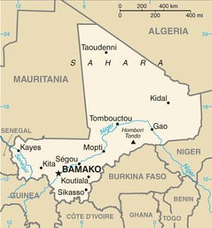
The city of Timbuctoo, at present in much decline and less populous, is situated on a plain surrounded by sandy eminences, about twelve miles north of the Nile el Abeede (River Niger) and three days' journey from the confines of the Sahara; the city is about twelve miles in circumference, but without walls.
The town of Kabra, situated on the banks of the river, was its great commercial depot or port. By means of a water carriage east and west of Kabra, great facility is given to the trade of Timbuctoo, from whence the various articles of European as well as Barbary manufactures brought by the akabahr from the North of Africa (now in less quantities than before) are distributed to the different kingdoms and states of Soudan and the south. This great mart is resorted to by all nations of Central Africa, whither they bring the various products of their respective countries to barter for the European and Barbary manufactures.
The main circulating medium at Timbuctoo is (tibber) gold dust.
The houses of Timbuctoo have for the most part no upper apartments. They are rather spacious and of a square form, with an opening on the centre, towards which the doors open; they have no windows, but the doors are lofty. Contiguous to the entrance door is a building consisting of two rooms, called a duaria, in which visitors are received and entertained, so that they see nothing of the women. The men are excessively jealous of their wives.
The kings, since the death of Muley Ismael, are the sovereigns of Bambara. The name of the present potentate is Said Ben Woolo; he is black and a native of Jinnie, his usual place of residence, though he has three palaces in Timbuctoo.
|
| | |
see also: Maruitania News - Algeria - Senegal - Guinea - Niger
|
|
All of Mali is
one time zone at GMT,
with no Daylight Savings time.
|
Mali News
The Sudanese Republic and Senegal became independent of France in 1960 as the Mali Federation. When Senegal withdrew after only a few months, what formerly made up the Sudanese Republic was renamed Mali.
Rule by dictatorship was brought to a close in 1991 by a military coup - led by the current president Amadou TOURE - enabling Mali's emergence as one of the strongest democracies on the continent.
President Alpha KONARE won Mali's first democratic presidential election in 1992 and was reelected in 1997. In keeping with Mali's two-term constitutional limit, KONARE stepped down in 2002 and was succeeded by Amadou TOURE, who was subsequently elected to a second term in 2007. The elections were widely judged to be free and fair.
In 2012, rising ethnic tensions and an influx of fighters - some linked to Al-Qaida - from Libya led to a rebellion and military coup. Following the coup, rebels expelled the military from the countrys three northern regions, allowing terrorist organizations to develop strongholds in the area. With French military intervention, the Malian Government managed to retake most of the north. However, the governments grasp in the region remains weak with local militias, terrorists, and insurgent groups continuously trying to expand control. In 2015, the Malian Government and northern rebels signed an internationally mediated peace accord. Despite a June 2017 target for implementation of the agreement, the signatories have made little progress. Extremist groups were left out of the peace process, and terrorist attacks remain common.
Ibrahim Boubacar KEITA won the Malian presidential elections in 2013 and 2018. Aside from security and logistic shortfalls, international observers deemed these elections credible. Terrorism, banditry, ethnic-based violence, and extra-judicial military killings plagued the country during KEITAs second term. In August 2020, the military arrested KEITA, his prime minister, and other senior members of the government and established a military junta called the National Committee for the Salvation of the People (CNSP). In September 2020, the junta established a transition government and appointed Bah NDAW, a retired army officer and former defense minister, as interim president and Colonel Assimi GOITA, the coup leader and chairman of the CNSP, as interim vice president. The transition governments charter allowed it to rule for up to 18 months before calling a general election.
In May 2021, Colonel Assimi GOITA led a military takeover, arresting the interim president after a Cabinet shake up removed GOITAs key allies. GOITA was sworn in as transition president in June 2021 and Choguel Kokalla MAIGA was sworn in as prime minister. In January 2022, the Economic Community of West African States (ECOWAS) imposed sanctions against the transition government and member states closed their borders after the transition government presented a five-year extension to the electoral calendar. ECOWAS and the transition government continue to work to negotiate an acceptable electoral calendar.
CIA World Factbook: Mali
Area of Mali:
1.24 million sq km
slightly less than twice the size of Texas
Population of Mali: 21,359,722 (2023) | 13,443,225 (2009)
Languages of Mali:
French official, Bambara 80%
numerous other African languages
Mali Capital:
Bamako
BAMAKO CAPITAL DISTRICT WEATHER
Free Books on Mali (.pdfs)
...In North & Central Africa Heinrich Barth 1890
Travels through Central Africa to Timbuctoo
v1 Réné Caillié 1830
Travels through Central Africa to Timbuctoo
v2 Réné Caillié 1830
...Journey from Fas to Timbuctoo... 1781
Shabeeny 1820
Online Book Search Engines
Mali Reference Articles and Links
Wikipedia: Mali - History of Mali
BBC Country Profile: Mali
US State Department: Mali Profile
Maps of Mali
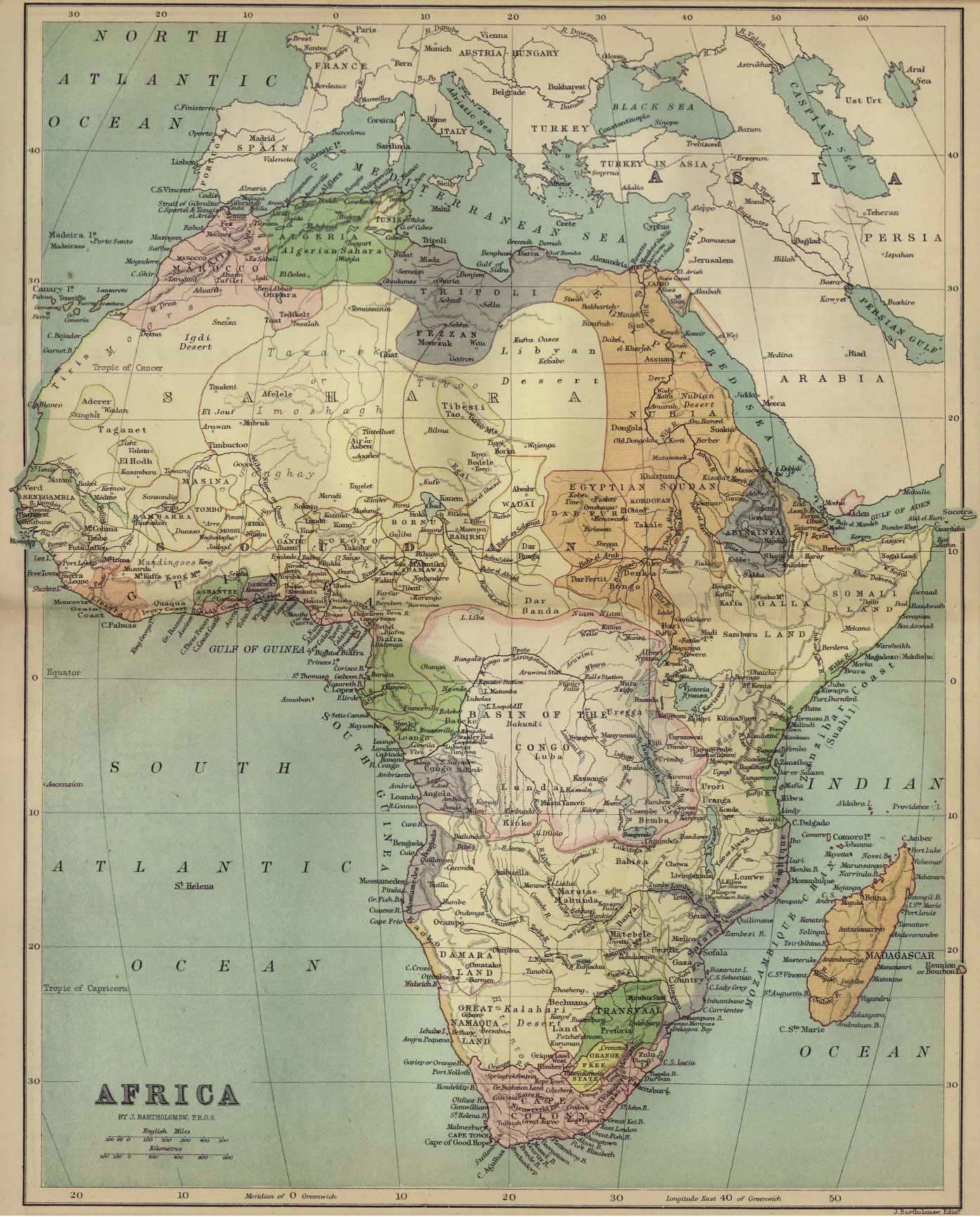
Historic Maps of Africa
1885 Map of Africa
Mali Embassy, Washington D.C.
WikiTravel: Mali
Mali News Websites
Journal du Mali
Panapress: Mali
ABYZ: Mali News Links
|