Jerusalem As It Was and As It Is,
1843 by Karl Johann Ball, p.115:
SECTION III.
I.
DESCRIPTION OF MODERN JERUSALEM.
Although the circumference of the ancient Jerusalem was, according to Josephus, about four miles, that of the modern city has been ascertained by accurate measurement not to exceed 12,978 feet; which difference is not surprising, as not only is the southern half of Mount Zion now without the walls, but also on the north the circuit of the ancient walls, which is about three quarters of a mile from the modern ones, formerly enclosed a considerable district, now lying without.
The modern walls were, as has been already noticed, built by the Sultan Solyman in 1542; they are forty feet high, and three broad, and have at regular intervals towers 120 feet high. They have on the whole an imposing appearance, being built entirely of hewn stone, with ramparts and battlements.
The gates are —the Jaffa or Hebron Gate, on the west; the road from which leads, on the right to Jaffa, and on the left to Bethlehem and Hebron; it consists of a massive square tower.
On the north is the Damascus Gate, called Bab el Amud, or the "gate of columns," by the natives. It is more ornamented than the other gates; the road hence leads to Damascus and northern Palestine.
Eastward of this, but still on the north side, is a small portal, in a tower of the city, called Herod's or Ephraim's Gate, which has however been lately closed up.
East of the city is St. Stephen's Gate, so called from an open space in front of it, where Stephen is said to have been stoned. It is called the Gate of the Tribes by the Mahommedans, and St. Mary's Gate by the native Christians; and is supposed to be the Sheep Gate mentioned in Scripture, Neh. iii. 1. Four lions are sculptured over this gate on the outside. It leads to Kedron, and the Mount of Olives; and over the latter to Bethany and Jordan.
Somewhat more southward, in the eastern wall, which encloses the mosque on Moriah, lies the Golden Gate; which has long been blocked up, because the Mahommedans, who call it the Eternal Gate, believe that a king shall one day enter through this gate, who shall take possession of the city, and become lord of the whole earth. Through this gate, Christ is said to have made his entrance into the city from the Mount of Olives.
Further on, in the southeast corner of the city, is a small entrance in a low square tower; which must have been a long while unused, since no trodden path, either within or without, leads to it.
On the south side of the city, in the valley between Moriah and Zion, is a small gate called "the Dung Gate," (Nehemiah it. 13), now blocked up; and upon Zion, over which the southern wall of the city crosses, is the Zion Gate, called "David's Gate" by the Mahommedans, which leads only to that part of Zion lying without the walls, and to the valleys of Jehoshaphat and Hinnom.
The principal streets of Jerusalem intersect each other at right angles; they are narrow and badly paved, yet being mostly situated on a declivity, are cleaner than those of most eastern towns.
The houses are of stone or clay; they are mostly low and irregular, without chimneys, and built with flat roofs, from the middle of which a cupola frequently rises. The windows are small, and often provided with iron trellises and wooden blinds, towards the streets, that the women may not be seen by passers by.
In order to become acquainted with the most important buildings of the city, let us enter by the Western or Jaffa Gate, and we have then on our right, directly to the south, the citadel of Jerusalem, 540 feet long and 162 wide, situate on the walls of the city, and called also the Pisan castle, and the fortress of David. It is an irregular combination of several square towers, encompassed on the inner side next the city, by a low wall, and on the outer or west side by a deep ditch.
A square tower, 70 feet wide, and 56 high, at the north-west angle, particularly attracts attention. It is called the Tower of David; and although its upper portion is of modern origin, its lower one bears evidence of great antiquity, and is beyond doubt a remnant of the tower of Hippicus, built by Herod.
Proceeding southward up the hill of Zion, we come to St. James's Church, the principal church of the Armenians, built on the spot where the Apostle James, son of Zebedee is said to have been beheaded by Herod; the building is devoid of taste, and filled with hideous pictures, but is richer and more magnificent than any other in the City. The adjoining convent of the Armenians has more than one thousand apartments for the reception of pilgrims, and is said to be the richest in the East; near it is shown the house of Hannah, with an Armenian chapel.
Upon the hill of Zion, without the walls, we are shown the house of Caiaphas, where is situate the Armenian church of the Redeemer, on the altar of which the true stone of the door of the Holy Sepulchre is said to be placed.
Near this is the Ccenaculum, in which it is said the Lord's Supper was instituted, the Holy Ghost poured out, and the Virgin Mary died. This building was formerly a Church, called Zion, or St. Mary's church, and belonged to the Franciscans; it is now a mosque, and the Mahommedans say that it stands over the grave of David.
The room where the Lord's Supper is said to have been instituted, is about 60 feet long, and 25 wide; and its roof is supported by two columns. In earlier times a Franciscan monastery also stood here.
Upon Mount Zion are the burying-places of the Armenians, Greeks, and Latins, as well as that of the American missionaries. There also the Protestant church is now in course of erection, a chapel having already been built for the performance of Divine service in the meantime.
The remaining part of this hill of the City of David, once entirely built over—the wall then passing round its southern side—is now arable land, where wheat is grown; so literally has the prophecy Micah iii. 12, and Jeremiah xxvi. 18, been fulfilled.
Upon Mount Zion, within the walls, lies also a Syrian convent; and on its eastern declivity, and in the valley between Zion and Moriah, is the Jewish quarter, the dirtiest and worst part of the city.
The chief building of Jerusalem, the mosque on Mount Moriah, is accessible to no Christian. Whoever is found there must either die or become a Mahommedan; because the Turks think that, according to 2 Kings viii. 30—50, every prayer made there is granted; and that Jews and Christians, if they were to enter therein, might pray that Jerusalem and the Temple might be restored to them. Permission to enter the mosque has been granted to only a very few individuals, as a great favour; and among these, an English physician, named Richardson, who had cured the governor of a disease in the eyes, was, in the year 1818, allowed, out of gratitude, to enter it four times.
The following description is principally taken from his narrative :—
On the top of the mountain is a square, called Haram esh Scherif (the noble Sanctuary), 1489 feet long, and 995 wide, bounded on the south and east by the walls of the town, and on the north and west, towards the city, by a wall of its own, which on the west is as much as sixty feet high.
Several gates lead from the city into this court. In the midst rises a platform fourteen feet high, paved with a bluish white kind of marble. Upon this stands the mosque, which is called Kubbet esh Sukhrah, i.e. the dome of the rock; or, according to others, Sakhara, i.e. fastened. It forms an octagon, each of whose sides is sixty feet long.
The lower part of the building is overlaid with white marble, and the upper with white, yellow, green, and blue tiles; and the whole inscribed with sentences from the Koran. Four doors lead into the interior. There are six windows in the sides that have doors, and seven in the others. The walls, in the inside, are white. Three columns, each twenty feet high, stand on each of the eight sides, and sixteen columns support the dome.
An iron trellis, between these columns, runs round the central space of the mosque. Here the Mahommedans pray, with their faces turned southward, towards Mecca. In the midst of the space surrounded with the trellis, lies a stone, upon which the Mahommedans say that the prophets prophesied; and that Gabriel held it down when it would have flown away, and fastened it to this place (hence the name Sakhara, or "fastened "), so that the marks of Gabriel's fingers are yet to be seen on it.
The native Christians believe this, or another kept there, to be the stone on which Jacob slept at Bethel (Gen. xxviii. 11) upon which the Destroying Angel who appeared to David sat; and which contains within it the Ark of the Covenant, hidden by Jeremiah.
The dome of the mosque is ninety feet high, and its diameter forty feet. It is covered with variegated tiles, and commands a magnificent view of the whole city. On the south, the enclosed space of the Haram esh Scherif contains also the mosque El Aksa—i.e. "the most distant;" because, with reference to the mosques of Mecca and Medina—which, with this, are the three most sacred places of the Mahommedans—it is the most distant from Arabia. It owes its origin, as we have already seen, to the Caliph Omar, who converted the then existing church of St. Mary into a mosque.
The presentation of Christ in the Temple being assigned to this spot, it was also formerly called the Church of the Presentation. In its vicinity the remains of subterraneous arches are also yet to be seen. Between the mosques Sakhara and El Aksa, is a marble basin or well, surrounded with olives, orange trees, and cypresses besides many things accounted holy by the Mahommedans. In every part of the ground, wherever the turf has been thrown up, are to be seen fragments of marble pillars; and the famous stone which projects from the eastern wall over the Valley of Jehoshaphat, and on which the Mahommedans say that Mahommed will one day be enthroned, and judge the world, is nothing else than the shaft of a broken column, thus embedded in the wall.
The southern part of Moriah, lying outside the walls of the mosque, which was anciently that part of the city called Ophel, inclines towards the south with a steep slope : it is ploughed up, and planted with olive and other fruit trees.
At the north-western angle of the wall, surrounding the square Haram esh Scherif, is the house of the Governor of Jerusalem, which contains the remains of the old Fort Antonia. Pilate is said to have lived there; and as it is situated in the "Via Dolorosa," we shall here take the opportunity of describing this the principal street of Jerusalem; of which, with its several stations, numerous models are to be found in all Roman Catholic countries.
It begins at St. Stephen's Gate, and leads over, the hill Bezetha; the buildings upon which are, for the most part, only low houses and hovels, while its north-eastern part, within the walls of the town, is covered with fields, gardens, and olive trees. There are also comparatively but few traces of ancient buildings to be found here. The house of Simon the Pharisee is pointed out near the ruins of the church of St. Mary Magdalene. It belongs to a Turk, who, however, allows ready access to Christians.
Entering the city from the Mount of Olives, through St. Stephen's Gate, and proceeding along the Via Dolorosa, we have the Sakhara mosque on the left; and a large reservoir, supposed to be the Pool of Bethesda, but more probably a trench which was thrown up for the defence of the Fort Antonia, lying close to its walls behind it. It is now quite dry, and is partly filled up with rubbish; yet, in other parts, still so deep, that the tops of trees growing at the bottom do not reach the level of the street. Opposite this pool, on the right of the Via Dolorosa, and over the grotto in which Anna is said to have brought forth the Virgin Mary, is a ruined church, with pointed arches, of the time of the Crusades...
|
| | |
see also: Syria News - Lebanon News - Egypt News - Jordan News
|
|
All Israel is at GMT+2, with DST from the last Friday before April 2
until the Sunday between
Rosh Hashanah and Yom Kippur
|
Israel News
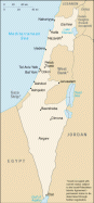
The State of Israel is located at the west (Asian) end of the Mediterranean Sea, bordered by Egypt, Jordan, Syria, and Lebanon. The capital is Jerusalem. The area of Israel is 7,992 square miles (20,700 square kilometers). The estimated population of Israel for 2023 is 9,043,387 (2009: 7,233,701).
Following World War II, the British withdrew from their mandate of Palestine, and the UN partitioned the area into Arab and Jewish states, an arrangement rejected by the Arabs. Subsequently, the Israelis defeated the Arabs in a series of wars without ending the deep tensions between the two sides.
On 25 April 1982, Israel withdrew from the Sinai pursuant to the 1979 Israel-Egypt Peace Treaty. In keeping with the framework established at the Madrid Conference in October 1991, bilateral negotiations were conducted between Israel and Palestinian representatives and Syria to achieve a permanent settlement. Israel and Palestinian officials signed on 13 September 1993 a Declaration of Principles (also known as the "Oslo Accords") guiding an interim period of Palestinian self-rule. Outstanding territorial and other disputes with Jordan were resolved in the 26 October 1994 Israel-Jordan Treaty of Peace. In addition, on 25 May 2000, Israel withdrew unilaterally from southern Lebanon, which it had occupied since 1982.
In April 2003, US President BUSH, working in conjunction with the EU, UN, and Russia - the "Quartet" - took the lead in laying out a roadmap to a final settlement of the conflict by 2005, based on reciprocal steps by the two parties leading to two states, Israel and a democratic Palestine. However, progress toward a permanent status agreement was undermined by Israeli-Palestinian violence between September 2003 and February 2005. An Israeli-Palestinian agreement reached at Sharm al-Sheikh in February 2005, along with an internally-brokered Palestinian cease-fire, significantly reduced the violence.
In the summer of 2005, Israel unilaterally disengaged from the Gaza Strip, evacuating settlers and its military while retaining control over most points of entry into the Gaza Strip. The election of HAMAS in January 2006 to head the Palestinian Legislative Council froze relations between Israel and the Palestinian Authority (PA).
Ehud OLMERT became prime minister in March 2006; he shelved plans to unilaterally evacuate from most of the West Bank following an Israeli military operation in Gaza in June-July 2006 and a 34-day conflict with Hizballah in Lebanon in June-August 2006. OLMERT in June 2007 resumed talks with the PA after HAMAS seized control of the Gaza Strip and PA President Mahmoud ABBAS formed a new government without HAMAS. OLMERT in September 2008 resigned in the wake of several corruption allegations, but remained prime minister until the new coalition government under former Prime Minister Binyamin NETANYAHU was completed in late March 2009, following the February general election.
While the most recent formal efforts between Israel and the Palestinian Authority to negotiate final status issues occurred in 2013-2014, the US continues its efforts to advance peace. Israel signed the US-brokered normalization agreements (the Abraham Accords) with Bahrain, the UAE, and Morocco in 2020 and reached an agreement with Sudan in 2021. Immigration to Israel continues, with more than 73,000 estimated new immigrants, mostly Jewish, in 2022.
The Israeli economy has undergone a dramatic transformation in the last 30 years, led by cutting-edge, high-tech sectors. Offshore gas discoveries in the Mediterranean, most notably in the Tamar and Leviathan gasfields, place Israel at the center of a potential regional natural gas market. In late 2022, a US-brokered agreement between Israel and Lebanon established their maritime boundary, allowing Israel to begin production on additional gasfields in the Mediterranean. However, Israel's economic prosperity is not consistently mirrored in the Israeli public's financial stability. Structural issues such as low labor force participation among religious and minority populations, low workforce productivity, high costs for housing and consumer staples, and high-income inequality, remain a concern for many Israelis and an important consideration for Israeli politicians.
Former Prime Minister Benjamin NETANYAHU returned to office in late 2022 continuing his dominance of Israel's political landscape at the head of Israel's most rightwing and religious government. NETANYAHU previously served as premier from 2009 to June 2021, becoming Israel's longest serving prime minister.
The CIA World Factbook: Israel
TEL AVIV WEATHER
Free Books on Israel (.pdfs)
The Culture of Ancient Israel Cornill 1914
A History of the Literature of Ancient Israel Fowler 1912
A Jewish State Herzl 1904
The Myths of Israel Fiske 1897
The History of Israel Ewald 1883
Phoenicia and Israel Wilkins 1874
The Land of Israel Keith 1855
Records of Israel Aguilar 1844
Jerusalem: Topography, Econ., History Smith v2 1908
Jerusalem: Topography, Econ., History Smith v1 1907
Inner Jerusalem Goodrich-Freer 1904
Jerusalem Besant 1888
Jerusalem As It Was and As It Is Ball 1843
Illustrations of Jerusalem & Mount Sinai Arundale 1837
Online Book Search Engines
Israel Reference Articles and Links
Wikipedia: Israel - History of Israel
BBC Country Profile: Israel
US State Department: Israel Profile
Maps of Israel
WikiTravel: Israel
Israel News Websites
Jerusalem Post
Ynet News
Haaretz
Globes Online financial news
ABYZ: Israel News Links
|