The New York Times, July 31, 1898, p.3:
THE CAROLINE ISLANDSValue and Beauty of the Islands of Spanish Micronesia
AN EXPLORER'S OBSERVATIONS
Topography, Products, and Natives of the Region
Where America May Locate a Coaling Station.
WASHINGTON, July 30.—Consul Doty of Tahiti, under date of July 8, 1898, sends a communication from F. W. Christian of the Polynesian Society of Wellington, New Zealand, a well-known explorer in the central Pacific. The letter contains an interesting description of the Caroline Archipelago, and is given, in part, as follows:
Spanish Micronesia, according to the treaty made with Germany in 1885, lies between the equatorial line to the south and the eleventh northern parallel and the meridians 139 degrees 12 minutes and 24 seconds and 170 degrees 12 minutes 24 seconds eastern longitude.
Six hundred and fifty-two islands lie scattered over this wide stretch of sea. The Spanish do not place the Mariannes (Ladrone Islands) in Micronesia; the large southernmost island, Guam or Guajan, lies some 550 miles to the north of Lamotrek. The Caroline Archipelago consists of thirty-six minor groups, of which the nine following are the principal: The Palaos or Pelews, Yap [Wa'ab], Uluthi [Ulithi], Uleai, Namonuito, Hogolen or Ruk [Chuuk, Truk], the East and West Mortlocks [Satawan], Bonabe or Ponapé [Pohnpei], and Kusaie [Kosrae], otherwise called Ualan or Strong's Island.
[Yap].
Yap is surrounded by a coral reef thirty-five miles long by five broad. There are hardly any rivulets, but inland are extensive swamps carefully planted with the water-taro (colocasia.) The island is full of relics of a vanished civilization—old embankments and terraces, sites of ancient cultivation, stone-paved roads, paes or ancient platforms of stone, faced with huge circular quartz wheels, set up at their sides; enormous council chamber lodges of quaint design, with bold, high, and projecting gables, and lofty carved pillars. Walls of ancient fish ponds and stone weirs fill the lagoon between the reef and the shore, making navigation a difficult matter.
There are some 8,000 natives on Yap—kindly, industrious, and generally peaceable folk, very dark in color, and speaking a quaint and barbarous dialect, much akin to that of the Pelews, yet with a certain family likeness to the isles further eastward, where the Polynesian infiltration appears to have been fairly strong.
The fruits of the soil are as follows: Sweet potatoes, yams, of which there is a great variety; taro, (lak,) mammee apples or pawpaws [papayas], pineapples, bananas, (pao,) sugar cane (maquil,) breadfruit (thau,) and the tropical almond (terminalia catappa.) Copra [dried coconut meat] is largely exported, mostly through German traders, who have spent a vast amount of money and labor here for many years past.
A varnish nut (adhidh) grows here, which should give good results. The principal timber tree is the tamanu, fetau or kamani of South Sea islands, the Callophyllum [Calophyllum] of botanists; the Yap natives call it voi.
Tomil Harbor is the place of European settlement, the seat of the Spanish Governor the the Western Carolines. There is a garrison of some 100 soldiers, with probably 150 political prisoners, captured in the late Philippine uprising. Tomil would be a good coaling station.
The Uluthi [Ulithi], or Mackensie, group lies a little to the northward of Yap. Mokomok, or Arrowroot, Island is the chief port and trading place. There is a great trade in copra here. The natives, since the ancient times, are subject to Yap, and come down about February each year to pay tribute to the chiefs of Tomil and Gochepa.
They are peaceful, industrious, and law-abiding, and great contrast to the people of Pulawat [Poluwat], or Enderly, further to the eastward, who have an ill-name as merciless and treacherous pirates throughout the length and breadth of the Carolines. The Uleai natives are better, but not quite trustworthy either.
Raur is the trading depot of this group. Much copra is produced, and turtle shell and béche de mer (pelipel) [sea cucumber] are collected. There are about 300 natives in this group. The language is Malayan mixed with Polynesian.
The Hall group, or Namonuito, and the group to the south, of which Pulawat and Pulo-Suk are the chief islands, are only to be visited with considerable precaution. It would be well for a man-of-war to visit here and warn the petty chiefs against piratical forays or cutting off peaceful trading vessels in their lagoons. The Spanish have taken little or no notice of several treacherous murders committed of late years, and seem disposed to let things still go on in the same haphazard fashion.
The next group eastward is called Ruk, or T'ruk, from the name of the tallest basaltic island in the chain (Ruk means "highland," or "lofty.") The group consists of some seventy islands lying in the midst of the great lagoon of Hologen, which name is also applied by some to the whole group. The lagoon is 210 kilometers (130.48 miles) round, and there is a fine depth of water and good anchorage for vessels of large draught.
There is a great annual output of copra. Pearl shell, tortise shell, and béche de mer are very abundant. The well-known island preparation of taik, a red cosmetic, is made here. The group has a population of some 10,000. Each island has its petty rajah.
The natives, both of Ruk and the neighboring group of the Mortlocks, have the curious custom, remarked in the Visayas of the Philippines, the Peruvian Indians, and the Taringa-Roroa aborigines of Easter Island, of piercing the lower lobe of the ear and forcing it to grow downward in a huge unsightly flap. The Mortlock language is the Lingua Franca of the Central Carolines. Here is found a very large Polynesian admixture.
The island of Losap, some eighty miles east of Ruk, has an ill reputation of late. It was colonized by a roving band of pirates from Chokach or Jekoits on the Penapé coast, and is said to have all the savage customs.
The Mortlocks consist of three groups. The population of the whole group is some 2,000. The products are copra and béche de mer. The Germans take great pains to develop industry here.
Of remarkable interest to philologists is the occurrence of a pure Polynesian dialect, apparently an antique form of Samoan, upon two islets named Greenwich and Kapin-Mailang, otherwise called Nuku-Oro [Nukuoro], lying to the south-southeast of Port Chamisso. The Spanish call them Pescadores. The inhabitants, numbering some 500, are honest, cheerful, and industrious.
Islands to the East.
We come now to the far eastern groups in the great chain, where the one hundred and seventieth north parallel divides the Spanish possessions from those of Germany. The most important part is that of Seniayina, Bonabe, or Ponapé [Pohnpei], which includes the Ant and Pakin Islands and the large island of Ponapé, (in native, Panu-Pei, or the Land of the Holy Places,) so called from the remarkable relics of ancient civilization found near Metalanim Harbor, on the east coast.
The island of Ponapé occupies 440,000 square kilometers, (170,324 square miles.) It is surrounded by an extensive reef, shutting in a wide lagoon studded on the north and southwest with many small islets. The country is occupied by five wei, or tribes, under their hereditary chiefs.
The territory of Chokach, or Jekoits, in the northwest, embraces the lofty island of that name, also Mount Paliker, and the valley of the Palang River on the mainland. The Pakin Islands, with their cocoanut groves, are also a dependency of the Prince of Chokach.
The last and the least of the tribes is that of Not, under the Chief Lapin-Not. The people live near the embouchure of the Pillapenchakola Creek, where it runs into Asuncion Bay in the north. On Asuncion Bay is the little Spanish colony with its slenderly garrisoned blockhouse and walled fort.
Near Metalanim Harbor, on the east, overlooking the bay, is a great artificial breakwater, nearly three miles long, inclosing some fifty walled islets, separated one from another by a network of shallow canals—a regular Micronesian Venice. The place is called Man-Matal, or the Place of the Waterways. On two of the islands—Nan-Tauach and Pankatara—are high walls inclosing an ancient sanctuary, where excavations made by us in 1896 brought to light a large number of stone and shell weapons and other relics of the past.
Port Lot, the residence of a local chief, David Lumpoi, a great scoundrel and deserving of no trust whatever, was a place of visit for the New England and New Bedford whalers. The water supply here is poor, provisions are ridiculously dear, and the natives of this particular district, for the most part, notorious rogues and thieves.
Port Mutok, at the mouth of the Kiti River, is good for wood and water; provisions are cheap, and the natives honest and well disposed. Henry Nanapei of Ronkiti, King Rocha of Kiti, his nephew, Nanaua, the Nan-keron of Mutok, and others have set the Kiti natives a noble example of fair dealing.
The Harbor of Ronkiti is some fifteen miles to the west of Mutok. There are plenty of pigs and fowls; yams, cocoanuts, bananas, and other tropical fruits may be procured here at moderate prices. Nanapei has planted the beautiful valley with cocoanuts and bananas. There is a well-attended Protestant mission school...
The chief products of Ponapé are copra, turtle shell, and ivory nuts. The last is the fruit of the och, an elegant palm resembling a sago palm, used for manufacturing buttons. Another valuable economic tree, the aig, is found bearing a large, circular reddish-brown nut, which makes good varnish. Sponges are obtained on the Paliker coast, near Palang, on the west, and béche de mer of good quality is found on the outer reefs off the Kiti and Metalanim coasts. The forests inland and salt marshes below are fairly rich in timber trees and wood useful for ornamental work.
There are plenty of pigs (puik) and dogs (kiti) some of them tailless, the latter much esteemed for food by the folk of Metalanim. On Mutok there are goats, and in the Ronkiti Valley Nanapei grazes some cattle...
The rivers are full of fish. There are eels of gigantic size and greatly dreaded by the natives, who will not eat their flesh. A venomous green snake, macho, is found occasionally in the salt marshes. There are several sea snakes and sea eels, some very beautifully colored. The sea is full of all manner of quaint, bizarre, and gorgeous forms of marine life.
There are many vegetable treasures in the bush, possessing very valuable medicinal properties. The pineapple, mango, sugar cane, and several sorts of banana and plantain, as well as yams and taro, grow abundantly. Breadfruit also grows in great magnificence, especially on the upper coast.
Further east from Ponapé are the Mokil, (or Duperrey,) the Pingelap, (or McCaskill,) and the Kusaie groups—the last of the Spanish dominions in Micronesia.
In conclusion, I would like to express the opinion that a great deal may be done with the islands of Kusaie and Ponapé, both of which deserve the name of the garden of Micronesia. Ruk and the Mortlocks, Yap and the Pelews also demand notice.
|
| | |
See also:
Indonesia News - Philippines - Taiwan
Papua New Guinea - Palau
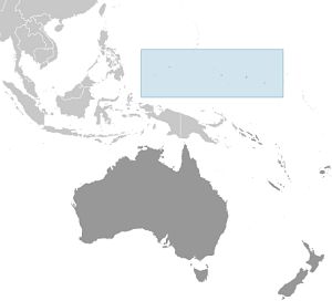
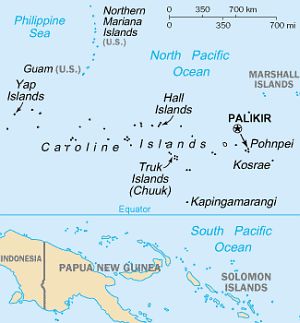
Micronesia covers 2 time zones, with Chuuk (Truk) & Yap at GMT+10, and Pohnpei (including the capital, Palikir) & Kosrae at GMT+11, with no DST
Micronesia News
Each of the four states that compose the Federated States of Micronesia (FSM) - Chuuk, Kosrae, Pohnpei, and Yap - has its own unique history and cultural traditions. The first humans arrived in what is now the FSM in the second millennium B.C. In the 800s A.D., construction of the artificial islets at the Nan Madol complex in Pohnpei began, with the main architecture being built around 1200. At its height, Nan Madol united the approximately 25,000 people of Pohnpei under the Saudeleur Dynasty. Around the same time, Kosrae was united in a kingdom centered in Leluh by 1250. Yaps society became strictly hierarchical, with chiefs receiving tributes from islands up to 1,100 km (700 mi) away. Widespread human settlement in Chuuk began in the 1300s, and the different islands in the Chuuk Lagoon were frequently at war with one another.
Portuguese and Spanish explorers visited a few of the islands in the 1500s and Spain began exerting nominal, but not day-to-day, control over some of the islands - which they named the Caroline Islands - in the 1600s. Christian missionaries arrived in the 1800s, in particular to Chuuk and Kosrae. By the 1870s, nearly every Kosraean had converted to Christianity and religion continues to play an important role in daily life on the island.
In 1899, Spain sold all of the FSM to Germany. Japan seized the islands in 1914 and was granted a League of Nations mandate to administer them in 1920. The Japanese navy built bases across most of the islands and headquartered their Pacific naval operations in Chuuk. The US bombed Chuuk in 1944 during Operation Hailstone in World War II, destroying 250 Japanese planes and 40 ships. The US military largely bypassed the other islands in its leapfrog campaign across the Pacific.
The FSM came under US administration as part of the Trust Territory of the Pacific Islands in 1947, which comprised six districts: Chuuk, the Marshall Islands, the Northern Mariana Islands, Palau, Pohnpei, and Yap; Kosrae was separated from Pohnpei into a separate district in 1977. In 1979, Chuuk, Kosrae, Pohnpei, and Yap ratified the FSM Constitution and declared independence while the other three districts opted to pursue separate political statuses. In 1982, the FSM signed a Compact of Free Association (COFA) with the US, which granted the FSM financial assistance and access to many US domestic programs in exchange for exclusive US military access and defense responsibilities; the COFA entered into force in 1986 and its funding was renewed in 2003. There are significant inter-island rivalries stemming from their different histories and cultures. Chuuk, the most populous but poorest state, has pushed for secession, but an independence referendum has been repeatedly postponed and may not be held.
Eligible Micronesians can live, work, and study in any part of the US and its territories without a visa - this privilege reduces stresses on the island economy and the environment. Micronesians serve in the US armed forces and military recruiting from the FSM, per capita, is higher than many US states.
CIA World Factbook: Micronesia
Area of Micronesia:
702 sq km
4x the size of Washington, DC
includes Pohnpei (Ponape), Chuuk (Truk) Islands,
Yap Islands, and Kosrae (Kosaie)
does not include Palau
Population of Micronesia:
100,319 (2023) | 107,434 (2009)
Languages of Micronesia:
English official, common
Trukese, Pohnpeian, Yapese, Kosrean,
Ulithian, Woleaian, Nukuoro,
Kapingamarangi
Micronesia Capital:
Palikir
PALIKIR WEATHER
Free Books on Micronesia (.pdfs)
Micronesia, 50 Years in the Island World... Bliss 1906
The Caroline Islands Christian 1899
11 years in New Holland
and the Caroline Islands O'Connell 1841
Online Book Search Engines
Micronesia Reference Articles and Links
Wikipedia: Micronesia - History of Micronesia
BBC Country Profile: Micronesia
US State Department: Micronesia Profile
Micsem.org: Micronesian Seminar
Maps of Micronesia
WikiTravel: Micronesia
Micronesia News Websites
ABYZ: Micronesia News Links
|